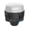


GINTEC G30 IMU RTK GNSS RECEIVER
With an advanced SoC board Mk-803,the GINTEC G30 now delivers an incomparable performance not only on fixing speed, accuracy, flexibility,low power consumption, but also reliability in complex environment. GINTEC G30 supports the BeiDou-3 B2b L-band BDS-PPP corrections to get real time centimeter level positioning services.It achieves centimeter precision in seconds while fully tracking GPS, GLONASS, BEIDOU, GALILEO and QZSS signals.”FIXED-KEEP” is possible for G30 to keep centimeter-level accuracy for few minutes if the RKT correction is lost.
· Mk-803 SoC board
· 965 channels
· 5 Satelittes + 16 Frequencies
· Internal radio working range 6KM
Contact Us for Best Price
Description
New Powerful RTK Engine
G30 is equipped with powerful GNSS RTK engine, which has 965 channels and support to capture all the running satellite signals. This RTK engine can effectively suppress signal interference. Even in complex environment, it still can provide users with reliable location information service
New Generation SOC Chip
G30 is integrated with advanced SOC chip, which comes with high integration, small size, low power consumption and fast running speed
Small and Light Design
G30 adopts highly integrated layered design to ensure performance and endurance while considering portability of outdoor work. Its weight is only 888g
Long-endurance Working Time
The built-in 6800mAh high-performance battery can support 15 hours long working time. With PD fast charging, the battery can be fully charged in 3 hours. The Type-C interface can support portable battery to charge G30
Base Moving Alert
With the built-in tilt attitude module, G30 can read the attitude information in real time. When the set-up Base receiver was accidentally moved, it can immediately send alert to remind users
Built-in Integrative Radio
The built-in transceiver integrated radio is compatible with multiple general protocols. And it adopts Farlink communication protocol for the first time which can greatly improve the signal receiving sensitivity, suppress the signal attenuation in the transmission process, and achieve long-distance working range 6km
IMU Tilt Survey
G30 is integrated with new generation IMU measurement unit which can make tilt survey more stable and accurate without magnetic field interference. User can easily finish surveying while walking and doesn’t’ need to adjust balance strictly.
Specification
| GNSS | |||||||||
| Channels | 965 | ||||||||
| Satellites | GPS: L1 C/A, L2C, L2P, L5 | ||||||||
| GLONASS: L1C/A, L1P, L2 C/A, L2P | |||||||||
| BeiDou: B1, B2, B3 | |||||||||
| BeiDou Global Signal: B1C, B2a, B2b | |||||||||
| Galileo: E1, E5a, E5b, E6, E5 AltBOC | |||||||||
| SBAS: WAAS, EGNOS, MSAS, GAGAN, SDCM | |||||||||
| QZSS: L1, L2C, L5 | |||||||||
| IRNSS: L5 | |||||||||
| L-Band: Optional | |||||||||
| Cold Start | <30s | ||||||||
| Accuracy | |||||||||
| Static Accuracy | Horizontal:±(2.5mm+1ppm) | ||||||||
| Vertical:±(5mm+1ppm) | |||||||||
| RTK Accuracy | Horizontal:±(8mm+1ppm) | ||||||||
| Vertical:±(15mm+1ppm) | |||||||||
| IMU Tilt Angle | 0°~60° | ||||||||
| IMU Accuracy | 10 mm + 0.7 mm/°tilt (1.8m pole) | ||||||||
| Update Frequency | 5Hz(up to 20Hz raw data collection) | ||||||||
| Signal Recapture | <1s | ||||||||
| POWER | |||||||||
| Battery | Internal Li-on, 6800mAh, 7.2V | ||||||||
| Duration | >15h | ||||||||
| Input | 6-28V DC, Overvoltage protection | ||||||||
| Physical | |||||||||
| Material | Magnesium aluminum alloy shell | ||||||||
| Dimension | 135mm (Diameter)x84mm (Height) | ||||||||
| Weight | 888g | ||||||||
| Operation | |||||||||
| Button | One button operation | ||||||||
| Indicator | 4 indicators | ||||||||
| Voice Prompt | Support for multiple languages: | ||||||||
| Chinese, English, Russian, | |||||||||
| Portuguese, Spanish, | |||||||||
| Turkish France and user define | |||||||||
| Web UI | Support to access Web UI via | ||||||||
| Wi-Fi and USB | |||||||||
| SYSTEM | |||||||||
| Operation System | Linux | ||||||||
| Memory | 4GB Internal Storage | ||||||||
| Bluetooth | Bluetooth 3.0/4.1, | ||||||||
| Bluetooth 2.1 + EDR standard | |||||||||
| NFC | Support | ||||||||
| WIFI | 802.11 b/g standard | ||||||||
| WIFI Data Link | To work as the datalink that receiver | ||||||||
| is able to broadcast and receive | |||||||||
| differential data via WIFI | |||||||||
| Mobile Network | LET FDD: B1/B3/B5/B7/B8/B20 | ||||||||
| LET TDD: B38/B40/B41 | |||||||||
| WCDMA: B1/B5/B8 | |||||||||
| GSM:850/900/1800/1900MHZ | |||||||||
| Internal UHF | Power: 1W | ||||||||
| Frequency: 410~470MHz | |||||||||
| Work Distance≥6km | |||||||||
| Protocol | SOUTH, Farlink, Trim Talk, Hi-target, CHC, Satel | ||||||||
| Data Transmission | USB data transmission and FTP/HTTP data download | ||||||||
| Data Format | Differential data format: | ||||||||
| RTCM 3.X, RTCM2.X, CMR, sCMRx, | |||||||||
| DGPS, RTCA, NOVATELX | |||||||||
| GPS output data format: NMEA 0183, PJK plane coordinates, | |||||||||
| Binary code | |||||||||
| Network model support: VRS, FKP, MAC, fully support NTRIP protocol | |||||||||
| Tilt Survey | IMU Tilt Survey Compatible with SurPad and CreateYours | ||||||||
| INTERFACE | |||||||||
| TNC | UHF Antenna | ||||||||
| Type-C | Charge and Data Transmission | ||||||||
| 5pin | NMEA Out Put | ||||||||
| Other | Micro SIM Slot | ||||||||
| ENVIRONMENT | |||||||||
| Work Temperature | –25 °C~+65 °C | ||||||||
| Stock Temperature | –35 °C~+80 °C | ||||||||
| Waterproof/Dustproof | IP68 Standard | ||||||||
| Shock and Vibration | Withstand 2 meters pole drop | ||||||||
| Humidity | 100% | ||||||||


Reviews
There are no reviews yet.