
Garmin Edge 530
Performance GPS Cycling/Bike Computer with Mapping, Dynamic Performance Monitoring and Popularity Routing
Features :
| Screen Size | 2.6 Inches |
| Special Feature | Bluetooth |
| Connectivity Technology | Bluetooth, ANT+, Wi-Fi |
| Map Type | Worldwide, North America |
| Sport | Cycling |
| Included Components | Edge 530; Standard mount; Flush out-front mount; Tether; USB cable; Documentation |
| Battery Life | 20 Hours |
| Mounting Type | Wrist Mount |
| Color | Black |
Contact Us for Best Price
Description
About this item
- Performance GPS cycling computer with mapping. Compatible with Vector (power meter). Power meter compatible (displays power data from compatible third-party ANT Plus-enabled power meters)
- Dynamic performance monitoring provides insights on your VO2 max, recovery, training balance, heat and altitude acclimation, nutrition, hydration and more when paired with compatible sensors
- Cycling safety features include new bike alarm, group messaging and tracking, assistance and compatibility with Variant rearview radar and lights so you can see and be seen (when device is paired with your compatible smartphone)
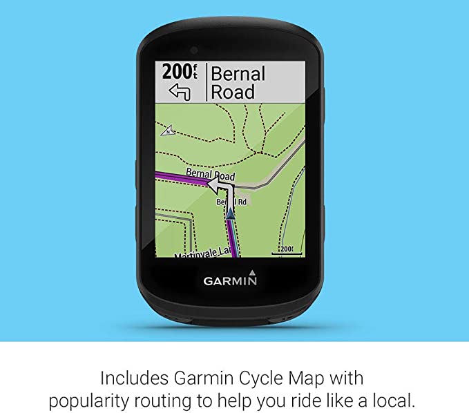
- Includes routable Garmin Cycle Map with popularity routing — which helps you ride like a local — plus off-course recalculation and back to start; mountain biking model has integrated Trail forks data, including trail difficulty ratings
- Customize with free apps, widgets and data fields from the Connect IQ Store
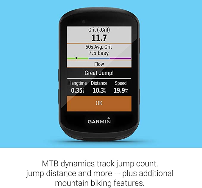
- MTB dynamics track jump count, jump distance and hang time as well as Grit, a measure of the ride’s difficulty, and Flow, which tracks the smoothness of your descent so you have a score to beat next time
- Battery life: up to 20 hours with GPS; works with Garmin Charge power pack for up to 40 hours of additional battery life
Specification
Signal Tracking
- Channels, which are simultaneously tracked: 572
- GPS: L1, L2, L2C, L5
- GLONASS: L1, L2
- GALILEO: E1, E5a, E5b
- BEIDOU: B1, B2, B3
- QZSS: Yes (reserved)
- SBAS: WAAS, EGNOS, MSAS, GAGAN
Performance Specifications
- Cold start: < 50 s
- Warm start: < 30 s
- Hot start: < 15 s
- Initialisation time: < 10 s
- Signal reacquisition: < 2 s
- Initialisation reliability: > 99.9 %
- Tilt sensor: Up to 30°
Positioning Specifications
- Static:
– Horizontal: 2.5 mm + 0.5 ppm RMS
– Vertical: 5.0 mm + 0.5 ppm RMS - Real-time kinematic(RTK)
– Horizontal: 8.0 mm + 1 ppm RMS
– Vertical: 15.0 mm + 1 ppm RMS - E-RTK (< 100 km)
– Horizontal: 0.20 m + 1 ppm RMS
– Vertical: 0.40 m + 1 ppm RMS - DGPS: < 0.4 m RMS
- SBAS: 1 m 3D RMS
- Stand-alone: 1.5 m 3D RMS
Data Communication
- 1 serial port (7-pin LEMO) baud rates up to 921,600 bps
- UHF modem Tx/Rx with a frequency range from: 410−470 MHz
- Transmitting power: 0.5 − 2 W
- Range 1 − 5 km
- Wi-Fi/4G modem:
4G bands: 800 / 900 / 1,800 / 2,100 / 2,600 MHz
3G bands: 900 / 2,100 MHz
2G bands: 900 / 1,800 MHz - Support GSM, point to point/points and NTRIP:
- Position data output rates: 1 Hz, 2 Hz, 5 Hz, 10 Hz, 20 Hz
- 5 LEDs: Indicating power, satellite tracking, GPRS status and
differential data - Bluetooth®: V 4.0 protocol, compatible with Windows OS
and Android OS
Data Format
- Correction data I/O: RTCM 2.X, 3.X, CMR, CMR+
(GPS only) - Position data output:
- ASCII: NMEA-0183 GSV, RMC, HDT, VHD,
GGA, GSA, ZDA, VTG, GST; PTNL,
PJK; PTNL, AVR; PTNL, GGK - geo-FENNEL Binary update to: 20 Hz
Physical
- Size: Ø 15.8 cm × 7.5 cm
- Weight: 0.95 kg with two batteries
Environmental
- Operating temperature: -40 °C to + 65 °C
- Storage temperature: -40 °C to + 85 °C
- Humidity: 100% condensation
- Waterproof and dustproof: IP67
- Shockproof: Designed to survive a 2 m drop onto
concrete
Electrical and Memory
- Input voltage: 5−27 VDC
- Power consumption: 3.1 W
- Power supply: 2 × 2,000 mAh, up to 9 hours typically
- Internal memory: 8 GB
Includes :
-
Depends on the constellation
of additional field controller
and usage as base/rover or
network system.


Reviews
There are no reviews yet.