
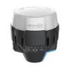


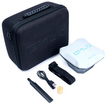
EMLID REACH RS+ GNSS RECEIVER
EMLID RS+ KEY FEATURES
Powerful, portable, weatherproof
The Emlid RS+ is packed with features to make it an industry-leading solution. These include:
Multi-support System: Tracks GPS, GLONASS, BeiDou, Galileo, QZSS, and SBAS.
Long-range Radio: LoRa with frequency range 868/915MHz for reliable connection with distances of up to 8km.
Dual-feed Antenna: With tight phase centre variation.
Polycarbonate Body: The Reach RS+ is durable and impact resistant. Its body is made of polycarbonate – an extremely durable material that is used in bulletproof glass.
30-hour Battery: LiFePO4 battery; external 6–40 V input; charges over USB from a powerbank.
Water and Dustproof: IP67: Work in dusty areas or under the rain. Rugged and hardy, the Reach RS+ can operate in temperatures from -20°С to 65°С.
8GB of Storage: Built-in memory for logs.
Contact Us for Best Price
Description
High-precision single-band GNSS receiver
The Reach RS+ is a high-precision single-band GNSS receiver, providing 1cm accuracy.
It can be used for RTK and PPK data collection.
The Reach RS+ is shockproof, has IP67 water and dust protection and works all day on one charge with an industrial battery that doesn’t die on cold.
This high-precision receiver can be deployed in numerous ways, including marking spots for piles on construction sites, to place ground control points, and laying out archeological sites.
It comes with the mobile app, ReachView. It can be used to collect and stake out points and control all features of the device.
The Reach RS+ is a powerful yet cost-effective solution, compared to other receivers on the market.
PPK SYSTEM FOR UAV MAPPING
Use fewer GCPs with centimetre accuracy
Reach logs precise tracks and the exact moment when each photo is taken.
The time and coordinates of each photo are logged with a resolution of less than a microsecond.
This means that the number of checkpoints can be reduced – and allows GCPs to be used only to check your accuracy – and enables the creation of precise 3D models.
Compatibility
Use Reach RS+ to set up your own base station. Stream corrections over the network via NTRIP/TCP or LoRa radio. Record base logs for post-processing.
Correction format: RTCM3
Log format: RINEX 2.0, RINEX 3.0
Max distance from a base: Up to 10 km in RTK; Up to 20 km in PPK.
Reach RS+ works seamlessly with other Reach receivers over any link.
Surveying with ReachView 3
Powerful data collection software for Emlid Reach
ReachView 3 is an intuitive software for data collection. It is available for Android and iOS.
ReachView 3 provides everything in one app: Collect and stake out points using your local coordinate system and control your Reach RS2 unit. Set up a base station, log RINEX data, configure NMEA output and manage survey projects.
The ReachView 3 supports thousands of different coordinate systems worldwide. The selection is based on the EPSG and IGN registries. The ReachView 3 has a custom tool for manual coordinate system creation for areas without a predefined coordinate system.
Specification
Emlid Reach RS+ Product Specification
| Specification | Value |
|---|---|
| Mechanical | |
| Ingress Protection | IP67 |
| Dimensions | 145 x 145 x 85mm |
| Weight | 690g |
| Operating Temperature | -20°С to +65°С |
| Electrical | |
| Autonomy | Up to 30 hours |
| Charging | Micro USB 5 V |
| External Power Input | 6–40V |
| Certification | FCC, CE |
| Battery | LiFePO4 3.2 V |
| GNSS | |
| Signals | GPS/QZSS L1, GLONASS G1, BeiDou B1, Galileo E1, SBAS |
| GPS / GNSS | 14Hz / 5Hz |
| Number of Channels | 72 |
| IMU | 9DOF |
| Positioning | |
| Static Horizontal | 5mm + 1ppm |
| Static Vertical | 10mm + 2ppm |
| Kinematic Horizontal | 7mm + 1ppm |
| Kinematic Vertical | 14mm + 2ppm |
| Data | |
| Corrections | NTRIP, RTCM3 |
| Position Output | NMEA, LLH/XYZ |
| Data Logging | RINEX with events; Up to 14 Hz |
| Internal Storage | 8 GB |
| Connectivty | |
| LoRa Radio | Up to 8km; 868 / 915MHz |
| Wi-Fi | 802.11 b/g/n |
| Bluetooth | 4.0/2.1 EDR |
| Ports | RS-232, Micro USB |


Reviews
There are no reviews yet.