


Comnav T300 GNSS Receiver
With SinoGNSS Quantum technology and fully integrated design, the T300 GNSS receiver is one of the most reliable choices for any surveying task. Strong signal tracking ability, hot swap battery and rugged housing design make the T300 perfectly and effectively work even in harsh environments.
SinoGNSS T300 GNSS receiver is a compact RTK GNSS receiver tracking all working constellations, combines 4G/TX & RX into one device, and works fluently with any Survey software, for centimeter accuracy survey on demand.
| 572 | |
| 30° | |
| 4G | |
| 410 – 470MHz | |
| GPS | L1, L2, L2C, L5 |
| GLONASS | L1, L2 |
| GALILEO | E1, E5a, E5b |
| BEIDOU | B1, B2, B3 |
Contact Us for Best Price
Description
Featuring full-constellation tracking capability, tilt compensation, 4G/WiFi connection, 8 GB internal memory and easy survey work ow with Android-based Survey Master Software, the T300 Plus GNSS receiver is one of the most reliable choices for your demanding surveying tasks. Collect more accurate data easier and faster no matter for beginners or professional surveyors
- GPS L1/L2/L5,
- BeiDou B1/B2/B3,
- GLONASS L1/L2,
- Galileo E1/E5a/E5b
- Compact Design
- Hot Swap Battery
- User-friendly Interface
- Support Long Baseline E-RTK
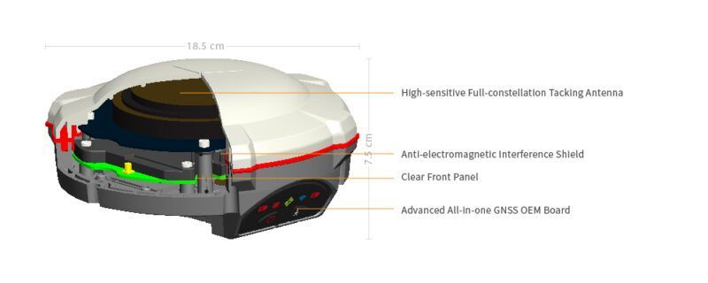
FULL-CONSTELLATION TRACKING
572 channels tracking all working and planned GNSS constellations
ADJUSTABLE TX & RX INTERNAL UHF*
Integrated UHF ranges from 410 to 470 MHz with 12.5 KHz channel spacing.
HOT SWAP CONSUMER-GRADE BATTERY
Two hot swap batteries ensure you fluent work ow in the eld. Consumer-grade battery design, compatible with Cannon LP-E6, makes it’s easy to replace in local markets.
SMART-CHARGING DESIGN
Use the T300 Plus as a battery charger so that you can charge the T300 Plus with a 12 VDC adaptor or a car battery.
TILT COMPENSATION
Up to 30° tilt compensation allows you collect high accurate data faster in the eld.
SEAMLESSLY WORK WITH NETWORKING RTK POSITIONING
Its built-in 4G modem ensures the T300 Plus perfectly works with all kinds of CORS worldwide.
WIFI CONNECTION
WebUI offers simple con configuration, operation, status of the T300 Plus.
USB MODE
When connecting the T300 Plus to your PC, you just copy the logged static data from the receiver to your PC.
SINOGNSS COMPASS SOLUTION SOFTWARE
- Provides the complete GPS/GLONASS/BeiDou/GALILEO processing solution
- Supports GNSS observation data in RINEX and ComNav Raw Binary Data formats
- Supports different post-processing in static and kinematic modes
- Outputs analysis reports in various formats (web format, DXF, TXT, KML)
SURVEY MASTER
- Compatible with most of Android devices
- Easier survey work ow via Wizard function
- Support maximum 30° tilt compensation
- Supports all survey modes, including Static, PPK and RTK
- Access to real-time open street maps
- Collect users’ feedback through Cloud Service
Specification
| Comnav T300 | |
| Signal Tracking | |
| Channels | 256 channels with simultaneously tracked satellite signals |
| GPS | L1 C/A, L1C, L2 P, L5 |
| BeiDou | B1, B2, B3 |
| GLONASS | L1, L2 |
| Galileo | Reserved |
| SBAS | WAAS, EGNOS, MSAS,GAGAN |
| Performance Specifications | |
| Cold start | <50s |
| Warm start | <30s |
| Hot start | <15s |
| Initialization time | 10s |
| Signal re-acquisition | <2s |
| Initialization reliability | Typically>99.9% |
| Positioning Specifications | |
| Post Processing Static | Horizontal: 2.5 mm + 0.5 ppm RMS |
| Vertical: 5 mm + 0.5 ppm RMS | |
| Real Time Kinematic | Horizontal: 8 mm + 1 ppm RMS |
| Vertical: 15 mm + 1 ppm RMS | |
| E-RTK (<100km) | Horizontal: 0.2 m + 1 ppm RMS |
| Vertical: 0.4 m + 1 ppm RMS | |
| Code differential GNSS positioning | Horizontal: 0.25 m+ 1 ppm RMS |
| Vertical: 0.5 m + 1 ppm RMS | |
| SBAS | Typically < 1 m 3D RMS |
| Standalone | <1.5 m 3D RMS |
| Communication port | 1 Serial port (7 Pin Lemo), Baud rates up to 921,600 bps |
| Radio modem | Tx/Rx with full frequency range from 410-470MHz2 |
| Transmit power: 0.5-2W adjustable | |
| Range: 1-4km | |
| Positioning data outputs | 1HZ, 2HZ, 5HZ, 10HZ, 20HZ |
| Indicating light | 5 LEDs (indicating Power, Satellite Tracking, Bluetooth® and Data Recording) |
| Bluetooth® | V 2.X protocol, work compatible with Windows 7, Windows mobile and Android |
| Data Format | |
| Data inputs/outputs | Correction data I/O: RTCM2.x, 3.x,CMR(GPS only), CMR+(GPS only) |
| Position data outputs | ASCII: NMEA-0183 GSV, RMC, HDT, VHD, GGA, GSA, ZDA, VTG, GST, PJK, PTNL |
| ComNav Binary update to 20Hz | |
| Physical | |
| Size(W×H) | 15.8cm×7.5cm |
| Weight | 0.95kg(include battery) |
| Environmental | |
| Operating temperature | -40 °C to +65 °C (-40°F to +149°F) |
| Storage temperature | -40 °C to +85°C (-40°F to +185°F) |
| Waterproof and dust proof | IP67 protected from temporary immersion to depth of 1 meter, floats |
| Shock | Survives a 2-meter drop on to concrete |
| Electrical | |
| Input Voltage | 5-27 VDC |
| Power consumption | 2.85 W(3 constellations) |
| Li-ion battery capacity | 2×2000 mAh, Up to 10 hours typically |
| Memory | 8 GB internal with up to 16GB pluggable memory card |
| Software | |
| CGSurvey | ComNav’s field data collection software CGSurvey |
| SurvCE (optional) | Carlson’s SurvCE field data collection software |
| FieldGenius (optional) | MicroSurvey’s FieldGenius field data collection software |


Reviews
There are no reviews yet.