
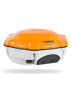

Leica Viva GS16 GNSS Smart Antenna
Meet the most compact and powerful self-learning GNSS smart antenna! The Leica Viva GS16 incorporates the leading RTK technology for the highest standards in measurement excellent with RTKplus and SmartLink. (Please note: SmartLink does not come as standard with out GS units, please contact us if you require a unit with the SmartLink function.) This clever GNSS receiver is able to be more selective about what signal it uses with RTKplus intelligently adapting to changing conditions.
With the Leica GS16, you get uninterrupted accurate positioning even when your local correction service is unavailable due to problems with network coverage. Even when no reference data is available, you can work fully remotely with SmartLink.
Features and Benefit
RTKplus
- 555 channels for more signals, faster acquisition and improved sensitivity
- Intelligent management of multi-frequency, multi-constellation signals
- Intelligent selection to automatically reject reflected or noisy signals
SMARTCHECK
- Unique RTK technology provides continuous checks to guarantee correct results
- Initialisation within seconds
- Complete reliability
SMARTLINK
- Achieve centimetre accurate positioning worldwide – perfect when working in remote areas around the globe
- No RTK base station or RTK network required, correction data is continuously transmitted by satellite delivering global coverage
- Bridging RTK outages for uninterrupted centimetre Positioning
BUILT FOR THE MOST DEMANDING ENVIRONMENTS
- IP68 protection
- Built for extreme temperatures of -40°C to +65°C
- Fulfils toughest standards throughout the complete product lifetime
ERGONOMICS
- Integrated mobile phone and UHF radio RTK devices
- Compact housing
- Lightweight
ONLINE SERVICES
- SmartNet Satellite Positioning – your No.1 partner for network RTK
- Leica Active Assist – the next level in support
- Leica Exchange – transfer data easily, quickly and safely
Contact Us for Best Price
Description
The Leica Viva GS16 is the most powerful and compact, self-learning GNSS smart antenna. Operating with the principal RTK technology, the Viva GS16 meets the uppermost standards in measurement superiority with SmartLink and RTKplus. The increasing number of signals from an expanding satellite constellation requires a GNSS receiver to be quicker and smarter. RTKplus intelligently adjusts to altering conditions by choosing the optimum signals to provide the most accurate positions. Work more efficiently and in more demanding environments than ever before.
Enjoy continuous precise positioning even if your local correction service is not available due to obstacles or shortage of cellular coverage with the global SmartLink service.
Engaging software
The Leica Viva GS16 GNSS smart antenna comes with the ground-breaking Captivate software, turning complicated data into the most realistic and workable 3D models. With easy-to-use applications and recognised touch technology, all forms of design and measured data can be viewed in all dimensions. Leica Captivate spans applications and industries with hardly any more than a swipe, regardless of whether you work with total stations, GNSS or both.
Infinite possibilities
While Captivate captures and models data in the field, Leica Infinity software processes the information back in the office. A smooth data transfer ensures the project stays on track. Captivate and Infinity work in conjunction to join previous survey data and edit projects faster and more efficiently.

Powerful handheld devices
The Leica CS35 tablet and CS20 controller provide the essential control, convenience and absolute mobility. Touch-screen technology allows for comfortable and fast data processing while an impressive 3D view transforms your experience.
Share data among instruments
Leica Infinity imports data from your GNSS, total station and level instruments for one complete and precise result. Processing has never been made easier when all your instruments work in together to produce accurate and actionable information.
Specification
GNSS TECHNOLOGY
| Self-learning GNSS | Leica RTKplus
SmartLink (worldwide correction service)
SmartLink fill (worldwide correction service) |
Adaptive on-the-fly satellite selection Remote precise point positioning (3 cm 2D)1
Initial convergence to full accuracy 20 – 40 min, Re-convergence < 1 min Bridging of RTK outages up to 10 min (3 cm 2D)1 |
| Leica SmartCheck | Continuous check of RTK solution | Reliability 99.99% |
| Signal tracking | GPS (L1, L2, L2C, L5), Glonass (L1, L2),
BeiDou (B1, B2, B32), Galileo (E1, E5a, E5b, Alt-BOC, E62), QZSS3, SBAS (WAAS, EGNOS, MSAS, GAGAN), L-band |
|
| Number of channels | 555 (more signals, fast acquisition, high sensitivity) | |
| MEASUREMENT PERFORMANCE & ACCURACY1 | ||
| Time for initialisation | Typically 4 s | |
| Real-time kinematic | Single baseline | Hz 8 mm + 1 ppm / V 15 mm + 1 ppm |
| (Compliant to ISO17123-8 standard) | Network RTK | Hz 8 mm + 0.5 ppm / V 15 mm + 0.5 ppm |
| Post processing | Static (phase) with long observations Static and rapid static (phase) | Hz 3 mm + 0.1 ppm / V 3.5 mm + 0.4 ppm
Hz 3 mm + 0.5 ppm / V 5 mm + 0.5 ppm |
| Code differential | DGPS / RTCM | Typically 25 cm |
| COMMUNICATIONS | ||
| Communication ports | Lemo Bluetooth® | USB and RS232 serial Bluetooth® v2.00 + EDR, class 2 |
| Communication protocols | RTK data protocols NMEA output Network RTK | Leica, Leica 4G, CMR, CMR+, RTCM 2.2, 2.3, 3.0, 3.1, 3.2 MSM
NMEA 0183 V 4.00 and Leica proprietary VRS, FKP, iMAX, MAC (RTCM SC 104) |
| Built-in data links | 3.75G GSM / UMTS / CDMA phone modem | Fully integrated, internal antenna |
| Radio modem | Fully integrated, receive and transmit, external antenna | |
| 403 – 470 MHz, 1 W output power, up to 28800 bps over air | ||
| External data links | GSM / GPRS / UMTS / CDMA and UHF / VHF modem | |
| GENERAL | ||
| Field controller and software | Leica Captivate software | Leica CS20 field controller, Leica CS35 tablet |
| User interface | Buttons and LEDs Web server | On / Off and Function button, 7 status LEDs
Full status information and configuration options |
| Data recording | Storage
Data type and recording rate |
Removable microSD card, 8 GB
Leica GNSS raw data and RINEX data at up to 20 Hz |
| Power management | Internal power supply External power supply Operation time4 | Exchangeable Li-Ion battery (2.6 Ah / 7.4 V) Nominal 12 V DC, range 10.5 – 28 V DC
7 h receiving (Rx) data with internal radio, 5 h transmitting (Tx) data with internal radio, 6 h Rx / Tx data with internal phone modem |
| Weight and dimensions | Weight
Diameter x Height |
0.93 kg / 2.90 kg standard RTK rover setup on pole 190 mm x 90 mm |
| Environmental | Temperature Drop
Proof against water, sand and dust |
-40 to 65°C operating, -40 to 80°C storage
Withstands topple over from a 2 m survey pole onto hard surfaces IP68 (IEC60529 / MIL STD 810G 506.5 I / MIL STD 810G 510.5 I / MIL STD 810G 512.5 I) |
| Vibration | Withstands strong vibration (ISO9022-36-08 / MIL STD 810G 514.6 Cat.24) | |
| Humidity | 100% (ISO9022-13-06 / ISO9022-12-04 / MIL STD 810G 507.5 I) | |
| Functional shock | 40 g / 15 to 23 msec (MIL STD 810G 516.6 I) |


Reviews
There are no reviews yet.